![]()
A Comprehensive introduction to all Britain's Waterways "where to
find them" and "what to see".
Many people can show you their local waterway. They regularly take a look, take a walk or take a picnic beside water.
This book shows you "where to find" over 50 others. Each map locates an individual river or canal in relation to the main road system. Each motorway junction is shown, as are any nearby tourist attractions and National Trails such as the Thames Path. Also suggested is "what to see" in over 400 places with a waterway interest. Each is described and directions given to help find it from a nearby motorway junction.
The complete listing is cross referenced to seven regional maps at the rear of the book.
21 "short strolls" are suggested - gentle circular walks taking about an hour. All strolls are easy walking, even for a family with a child's buggy. Most are accessible by public transport, many are not far from a railway station. Longer walks in the same area are also suggested.......for those with more time and energy.
There is full coverage
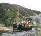
from Caledonian Canal in the
North, to the Wey and Arun in the SouthBrecon Beacons in the
West , to the Broads in the East.
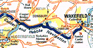
Most location maps are the same scale 1:350 000 (exceptions are BCN & Broads 1:250 000). All short stroll maps are the same scale at 1:15 000. All maps have North consistently at the top of the page.
Waterways guides are suggested and telephone numbers of trip boats and tourist information centres are given. A full index of all features, and a selection of web-sites.
Comments and corrections are welcomed by brian-roberts@cwcom.net

Brian Roberts.......A Gemini, has always been interested in waterways.
His first experience on the water was with Manchester University Boat Club, coxing their first eight at many regattas and at the Head-of the River races on the Thames.
After returning from being a colonial civil servant in the far east....where the rivers were often the only means of transport, he has lived in Surrey where the Wey meets the Thames.
When working in Oxford recently, he lived part-time on a well insulated narrow boat, and is now a part owner of one based in Lichfield. When researching this book, he travelled over 750 miles of the 3000 miles of waterway available today, countless miles by road, and, with his wife, explored most of the 21 "short strolls" more than once.
He is a member of the Railway and Canal Historical Society, and was sometime chairman of the Oxfordshire Branch of the Inland Waterways Association - a registered charity which started over 50 years ago campaigning for, amongst other things, the preservation of the ecological, architectural and heritage aspects of Britain's Waterways.